Autonomous Reasoning Systems

Tier-Scalable Reconnaissance

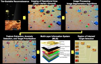
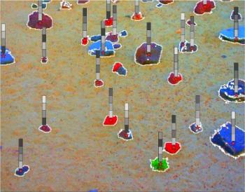
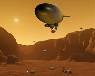
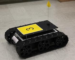
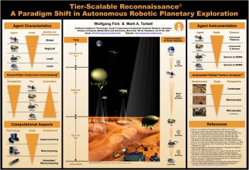
A fundamentally new scientific mission concept for remote planetary atmospheric, surface, and subsurface reconnaissance is replacing the engineering and safety constrained mission designs of the past, allowing for optimal acquisition of geologic, paleohydrologic, paleoclimatic, and possible astrobiologic information of Mars and other extraterrestrial targets. Traditional missions have performed local ground-level reconnaissance through rovers and immobile landers, or global mapping performed by an orbiter. The former is safety and engineering constrained, affording limited detailed reconnaissance of a single site at the expense of a regional understanding, while the latter returns immense datasets, often overlooking detailed information of local and regional significance. The ‘‘Tier-Scalable Reconnaissance’’ paradigm, originated by Dr. Wolfgang Fink at the Visual and Autonomous Exploration Systems Research Laboratory at Caltech and his collaborators (PSS 2005, see Publications), integrates multi-tier (orbit <=> atmosphere <=> ground/subsurface) and multi-agent (orbiter <=> blimps <=> rovers/landers/drills/sensorwebs) hierarchical mission architectures, not only introducing mission redundancy and safety, but enabling and optimizing intelligent, unconstrained, and distributed science-driven exploration of prime locations on Mars and elsewhere, allowing for increased science return, and paving the way towards fully autonomous robotic missions.

[Issued patent(s): U.S. 6,990,406, U.S. 7,734,063, and U.S. 7,742,845]


Sponsor(s):

AGFA: (Airborne) Automated Global Feature Analyzer

For the purposes of space flight, reconnaissance field geologists have trained to become astronauts. However, the initial forays to Mars and other planetary bodies have been done by purely robotic craft. Therefore, training and equipping a robotic craft with the sensory and cognitive capabilities of a field geologist to form a science craft is a necessary prerequisite. Numerous steps are necessary in order for a science craft to be able to map, analyze, and characterize a geologic field site, as well as effectively formulate working hypotheses. The Automated Global Feature Analyzer (AGFA), originated by Fink at Caltech and his collaborators in 2001, is an automatic and feature-driven target characterization system that operates in an imaged operational area, such as a geologic field site on a remote planetary surface. AGFA performs automated target identification and detection through segmentation, providing for feature extraction, classification, and prioritization within mapped or imaged operational areas at different length scales and resolutions, depending on the vantage point (e.g., spaceborne, airborne, or ground). AGFA extracts features such as target size, color, albedo, vesicularity, and angularity. Based on the extracted features,  AGFA  summarizes  the mapped operational area numerically and flags targets of “interest”, i.e., targets that exhibit sufficient anomaly within the feature space. AGFA enables automated science analysis aboard robotic spacecraft, and, embedded in tier-scalable reconnaissance mission architectures, is a driver of future intelligent and autonomous robotic planetary exploration.

[Issued patent(s): U.S. 9,122,956 and U.S. 9,424,489]


Sponsor(s):

Target Prioritization

The generic target prioritization framework, developed by Fink, addresses the problem of automated prioritization of target selection and instrument usage, applicable to Earth and Space reconnaissance missions. The framework is based on the assumptions that clustering of preliminary data for identified targets within an operational area has occurred and that the clustering quality can be expressed as an objective function. Target prioritization then means to rank targets according to their probability of changing the objective function value upon close reexamination. The mathematical formalism of the target prioritization framework allows for the calculation of these probabilities and the probabilities for instruments aboard a science craft to contribute to this change of the objective function value.


Sponsor(s):

Robotic Lake Lander Test Bed for Autonomous Surface and Subsurface Exploration of Titan Lakes

We introduce a robotic lake lander test bed that can be operated either stand-alone or as part of a Tier-Scalable Reconnaissance mission architecture to study and field test an integrated hardware and software framework for fully autonomous surface and subsurface exploration and navigation of liquid bodies. The lake lander is equipped with both surface and subsurface sensor technologies. Our particular focus is on Saturn’s moon Titan with its hydrocarbon lakes with respect to future missions involving lake landers (e.g., Titan Mare Explorer (TiME) mission), potentially in conjunction with balloons/airships and orbiter-support overhead. This test bed serves as an analog to a Titan unpiloted surface vessel equipped with its own onboard real-time navigation and hazard avoidance system, surface and subsurface exploration sensor suite, and autonomous science investigation software system. As such the test bed helps map out a technical path toward true autonomy for the robotic exploration of the Solar System.

[Issued patent(s): U.S. 6,990,406, U.S. 7,734,063, and U.S. 7,742,845]

Multi-Rover Testbed for Teleconducted and Autonomous Surveillance, Reconnaissance, and Exploration

At Caltech’s and UA's Visual and Autonomous Exploration Systems Research Laboratory an outdoor multi-rover testbed has been developed that allows for near real-time interactive or automatic control from anywhere in the world via the Internet. It enables the implementation, field-testing, and validation of algorithms/software and strategies for navigation, exploration, feature extraction, anomaly detection, and target prioritization with applications in planetary exploration, security surveillance, reconnaissance of disaster areas, military reconnaissance, and delivery of lethal force such as explosives for urban warfare. Several rover platforms have been developed, enabling testing of cooperative multi-rover scenarios (e.g., inter-rover communication/coordination) and distributed exploration of operational areas.

[Issued patent(s): U.S. 6,990,406, U.S. 7,734,063, and U.S. 7,742,845]


Sponsor(s):